

Introduction
Understanding how to convert multipolygons to individual polygons in PostGIS is crucial for spatial data management and analysis.
Spatial datasets often store multiple distinct areas as a single multipolygon geometry. While this format helps group related areas, individual polygons may be needed for more precise map visualization, geospatial analysis, or integration into logistics and business intelligence systems.
Whether you’re working with detailed regional boundaries, ZIP code zones, or delivery areas, converting multipolygon geometries into individual polygons allows for better spatial querying, improved mapping accuracy, and enhanced data integration in applications like business intelligence dashboards or logistics planning tools.
💡 Use accurate location data to convert multipolygons to polygons in PostGIS. Our worldwide ZIP code and boundaries data is updated weekly, relying on over 1,500 sources. Browse GeoPostcodes’ datasets and download a free sample here.
This guide will walk you through converting multipolygons to polygons in PostGIS, covering key concepts, best practices, and practical solutions to common challenges.
Understanding Polygons and Multipolygons in GIS
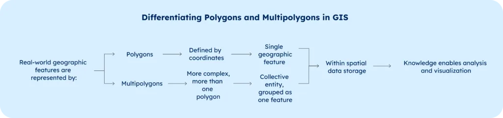
In Geographic Information Systems (GIS), polygons and multipolygons serve as fundamental building blocks for representing real-world geographic features, though they differ significantly in their structure and application. A polygon is a two or three-dimensional shape defined by a series of ordered x, y coordinates that form a closed boundary. Think of a polygon as a single parcel of land or a building footprint – one continuous area with clear boundaries.
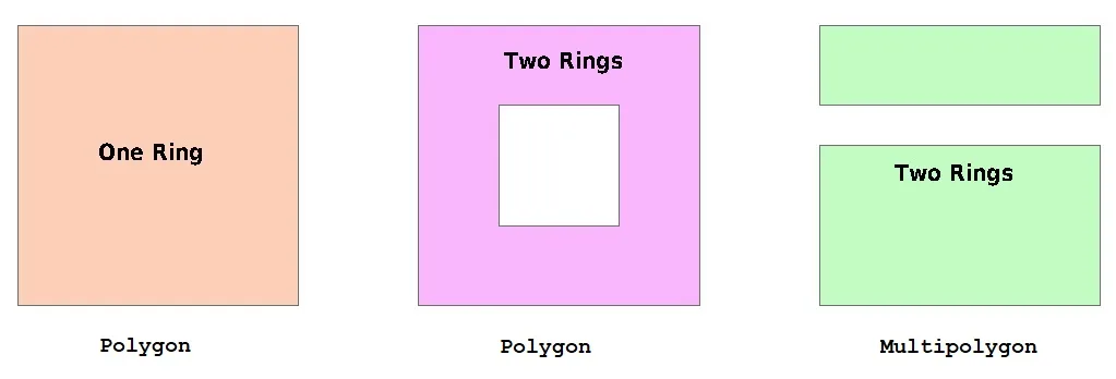
Multipolygons, on the other hand, are more complex structures that consist of multiple polygon features grouped together as a single entity. A classic example would be an archipelago, where each island is represented as a separate polygon, but collectively they form one multipolygon feature. This distinction is particularly important when working with spatial data that represents discontinuous geographic features.
For spatial analysts and GIS professionals, understanding these differences is not merely academic – it directly impacts how we store, analyze, and visualize spatial data. The ability to convert between these formats enables more flexible data analysis and can solve various spatial computing challenges.
Representing Polygons in PostGIS
PostGIS extends PostgreSQL’s capabilities by introducing the specialized geom geometry data type, which provides robust support for storing and manipulating spatial data. When working with polygons in PostGIS, you have multiple options for data representation and creation.

The most common method for creating polygons is using the ST_GeomFromText function, which accepts Well-Known Text (WKT) representation. Here’s an example:
CREATE TABLE land_parcels (
    id SERIAL PRIMARY KEY,
    parcel_geometry geometry(Polygon, 4326)
);

INSERT INTO land_parcels (parcel_geometry)
VALUES (
    ST_GeomFromText('POLYGON((0 0, 0 1, 1 1, 1 0, 0 0))', 4326)
);
In this example we have insert in our table ‘land_parcels’ perfect square.
Alternatively, you can use the ST_GeomFromWKB function for creating polygons from Well-Known Binary (WKB) format, which is particularly useful when working with binary spatial data:
INSERT INTO land_parcels (parcel_geometry)
VALUES (
    ST_GeomFromWKB(E'\\\\001...')
);
Converting Multipolygons to Separate Polygons
The ST_Dump function in PostGIS is the primary tool for converting multipolygons into their constituent polygons. This function returns a set of geometry_dump objects, each containing a path and a geometry component. You can find the details of the function here and a practical example below:
WITH multipolygon_data AS (
    SELECT ST_GeomFromText('MULTIPOLYGON(((0 0, 0 1, 1 1, 1 0, 0 0)),((2 2, 2 3, 3 3, 3 2, 2 2)))') as geom
)
SELECT (ST_Dump(geom)).geom AS single_polygon
FROM multipolygon_data;
In this example, the multipolygon consists of a single record containing two squares. By using ST_Dump, we obtain two separate records, each representing one square.
Working with Geom Geometry in PostGIS
The geom geometry data type in PostGIS is incredibly versatile, supporting various spatial data types and operations. Here are some essential functions for working with geometry objects:
-- Calculate area of a polygon
SELECT ST_Area(geometry_column) FROM your_table;

-- Calculate perimeter
SELECT ST_Perimeter(geometry_column) FROM your_table;

-- Check geometry type
SELECT ST_GeometryType(geometry_column) FROM your_table;
These functions provide crucial information about your spatial features and help ensure data integrity throughout the conversion process.
Best Practices for Converting Multipolygons
When converting multipolygons to individual polygons, following best practices ensures data quality and prevents issues downstream:
Always validate your geometries before and after conversion:
SELECT ST_IsValid(geometry_column) FROM your_table;
If your geometry is not valid you check the reason with ST_IsValidReason (see the description and examples of ST_IsValidReason).
SELECT ST_IsValidReason(geometry_column) FROM your_table;
Check for self-intersections:
SELECT ST_Intersects(a.geometry, b.geometry)
FROM your_table a, your_table b
WHERE a.id < b.id;
Maintain spatial indexes for better performance:
CREATE INDEX spatial_idx ON your_table USING GIST (geometry_column);
Troubleshooting Common Issues
Invalid geometries and self-intersecting polygons are common challenges when working with spatial data. Here’s how to address these issues:
For invalid geometries:
UPDATE your_table
SET geometry_column = ST_MakeValid(geometry_column)
WHERE NOT ST_IsValid(geometry_column);
The function ST_MakeValid aims to generate a valid representation of an invalid geometry without discarding any of the input vertices (more information in the function).
Conclusion
Converting multipolygons to separate polygons is a fundamental operation in spatial data management that requires a solid understanding of both the underlying concepts and the practical implementation in PostGIS. The process involves using specialized functions like ST_Dump while maintaining data integrity through validation and proper geometry handling.
Success in this area depends on:
- Understanding the fundamental differences between polygons and multipolygons
- Proficiency with PostGIS functions and the geom geometry data type
- Following best practices for geometry validation and error handling
- Implementing proper troubleshooting techniques when issues arise
By mastering these concepts and techniques, you’ll be better equipped to handle complex spatial data operations and maintain high-quality geographic information in your database systems. Use accurate geospatial data from GeoPostcodes to perform data-driven spatial analysis and techniques such as mapping, GIS analysis, and remote sensing. We invite you to browse GeoPostcodes datasets and download a free sample here.
FAQ
What is the difference between a polygon and a MultiPolygon?
A Polygon is a single closed shape with one exterior ring and optional interior holes. A MultiPolygon contains multiple separate polygons in one geometry object. In PostGIS, Polygons have a single shell with holes, while MultiPolygons can store disconnected polygon geometries under one feature.
How do you split a MultiPolygon into polygons in ArcGIS?
In ArcGIS, use the “Multipart To Singlepart” tool found in the Data Management toolbox under Features. This tool creates separate features for each polygon component while maintaining attribute data. The result is a new feature class with individual polygon geometries.
How to convert MultiPolygon to polygon in QGIS?
In QGIS, use Vector → Geometry Tools → Multipart to Singleparts. This creates a new layer where each part of the MultiPolygon becomes an individual Polygon feature. All attributes from the original features are preserved in each resulting polygon.
How do I convert a polygon ZM to a polygon in ArcGIS?
Use the “Feature Class to Feature Class” tool with “Coordinates System Transformation” and under Geometry Properties, set “Has Z Values” and “Has M Values” to disabled. Alternatively, use the “Drop Z/M” tool in the 3D Features toolbox to remove Z or M values.
How do I convert a MultiPolygon to a single Polygon in PostGIS?
To convert a MultiPolygon to Polygon in PostGIS, you need to ensure that your MultiPolygon contains only one polygon. If it does, you can use the ST_GeometryN() function:
SELECT ST_GeometryN(geom, 1) AS single_polygon FROM your_table;
If your MultiPolygon contains multiple polygons, you may need to first union them using ST_Union() before extracting a single polygon.
SELECT ST_Union(geom) AS single_polygon FROM your_table;
How do I handle a Geometry Collection when converting MultiPolygon to Polygon in PostGIS?
A Geometry Collection can contain different geometry types, including MultiPolygon and Polygon. To extract and convert MultiPolygon to Polygon in PostGIS, use ST_Dump(), which separates the multiple polygons into individual rows:
SELECT (ST_Dump(geom)).geom AS single_polygon FROM your_table;
This SQL query ensures that each geometry is processed separately, converting a Multi Polygon into distinct single Polygon geometries while preserving spatial accuracy.

