
Introduction
Location intelligence has become a cornerstone of smart business decisions. However, one detail that often gets overlooked is ZIP code granularity. This refers to the geographic precision built into ZIP codes, which can vary significantly from one country to another and directly impact all location-based business activities.
For global companies, understanding how ZIP code precision affects targeting accuracy, supply chain performance, and demographic analysis is essential for thoughtful strategic planning.
Whether mapping customer distribution, improving shipping routes, or defining sales territories, knowing how precise a country’s ZIP codes are can give you a real edge. It turns raw geographic data into clear, actionable insights.
Recognizing the differences in regional ZIP code structures is more than a nice-to-have—it’s a must for international businesses. Creating innovative, localized geographic strategies that match each country’s postal system isn’t just helpful—it’s often critical for cross-border success.
💡 For over 15 years, we have created the most comprehensive worldwide ZIP code database. Our location data is updated weekly, relying on more than 1,500 sources. Browse GeoPostcodes databases and download a free sample here.
The Fundamentals of ZIP Code Granularity
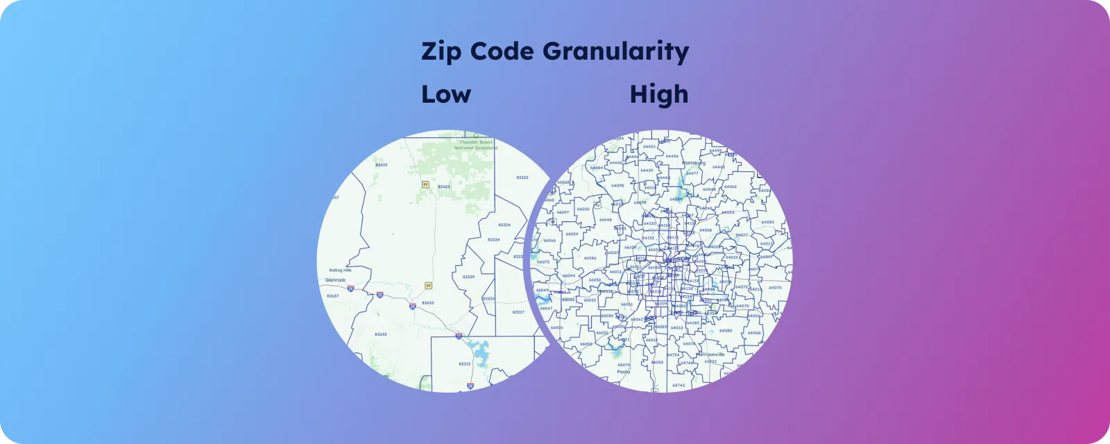
ZIP code granularity refers to how precisely a ZIP code identifies a location—from specific buildings to entire neighborhoods. These differences usually reflect each country’s unique geography and population distribution.
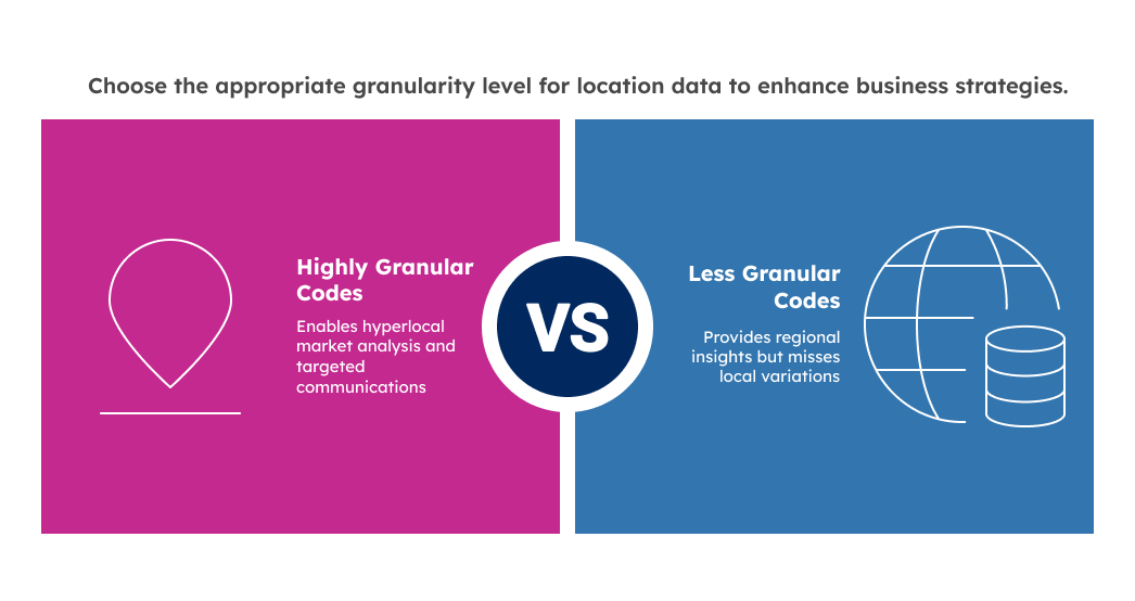
For businesses, that level of precision directly impacts market analysis, targeting, and logistics planning. Detailed codes can reveal hyperlocal trends, while broader ones offer a general regional view but may hide important local variations.
This leads to key differences between markets. For example, UK postcodes can show behavior at the street level, while other countries’ codes might only distinguish larger zones. To get accurate insights, businesses need to tailor their analysis to match each region’s granularity level.
Comparing Global Postal System Granularity
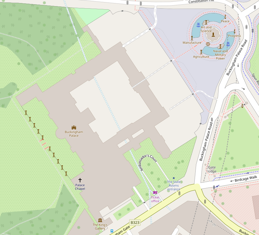
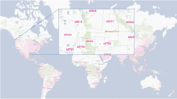
The UK is often seen as the gold standard for ZIP code granularity, thanks to its exact alphanumeric system. A full UK postcode like “SW1A 1AA” (yes, that’s Buckingham Palace) can cover as few as 15–20 addresses or even a single building. This level of detail lets businesses create highly targeted strategies based on specific geographic segments.
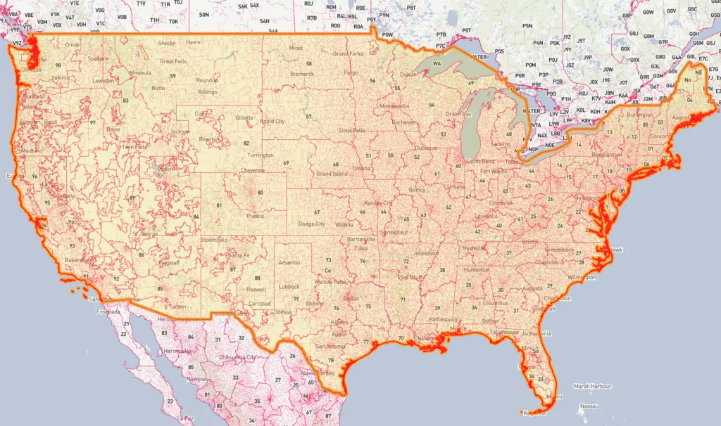
In contrast, the standard U.S. ZIP code—the familiar five-digit version—covers a much larger area, sometimes thousands of addresses across multiple streets or neighborhoods. The ZIP+4 format does increase precision by identifying smaller blocks, but it’s not consistently used.
Compared to the UK’s universally granular model, this creates challenges when analyzing or comparing location data across countries.
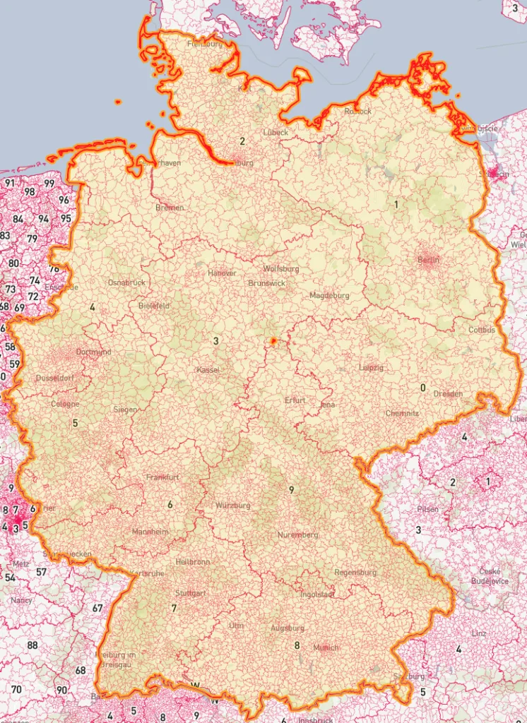
Other countries fall somewhere in between. Germany’s PLZ and France’s Code Postal offer strong urban accuracy but cover broader rural zones. Japan’s zip code system delivers excellent precision overall, despite the added complexity of managing so many address components.
These variations often include population density, urban development, and how each country’s postal system evolved. Understanding these differences is key to interpreting and applying location data effectively for global businesses.
The Business Impact of ZIP Code Granularity
Marketing and Customer Targeting
Granular ZIP codes make it possible to run hyper-local marketing campaigns, targeting specific streets, neighborhoods, or small communities. This lets businesses tailor offers to local demographics and shopping habits, leading to smarter ad spending and better conversion rates than broad, one-size-fits-all campaigns.
But what works well in markets with high granularity, such as the UK, might not perform the same in places with less detailed postal systems. These differences show just how important it is to adjust your targeting strategies based on the limitations of local location data.
Logistics and Route Optimization
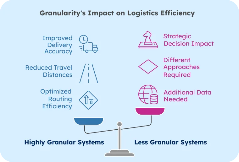
In logistics and delivery, ZIP code granularity plays a big role in how efficient your routes are and how much they cost. Detailed postal systems make pinpointing exact delivery locations and planning routes easier. This means shorter travel times, better delivery estimates, and lower fuel costs.
However, when working in countries with broader ZIP codes, you may need extra data or alternate routing methods to achieve the same level of accuracy.
Granularity also affects larger decisions, such as where to place warehouses, how to design distribution networks, and how to define service areas.
Leading companies know this and build flexibility into their logistics models. Understanding the precise ZIP codes in each region is the first step to reliable delivery and accurate service coverage.
Overcoming ZIP Code Granularity Challenges
Different levels of ZIP code granularity around the world can make data integration tricky, especially for multinational companies. When location data isn’t equally precise across markets, it can lead to inaccurate insights and costly strategic missteps.
That’s where GeoPostcodes steps in. Our global database uses consistent formatting and includes extra data fields that help fill the gaps in lower-resolution postal systems.
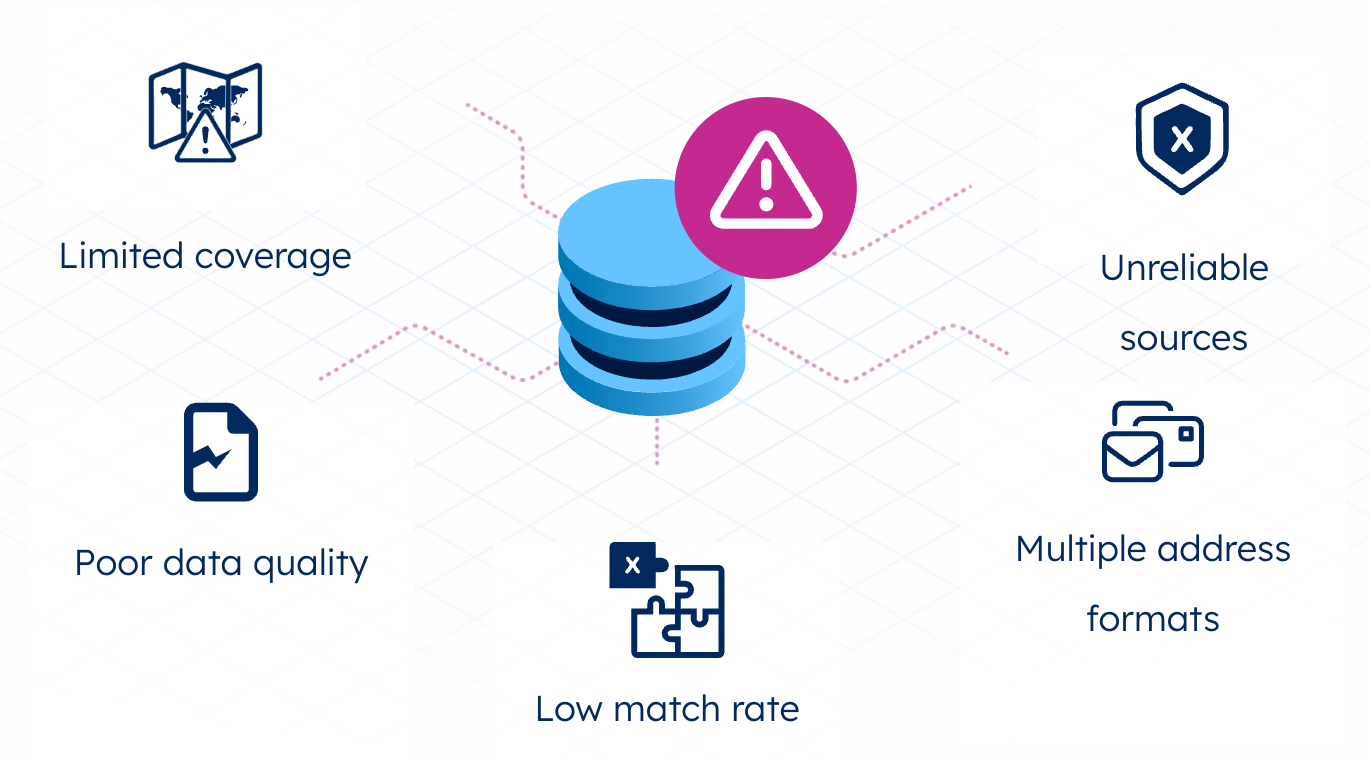
We provide detailed geocoordinates, boundary data, and hierarchical administrative data to give you a clearer picture, even in areas with broad or outdated ZIP codes. With our standardized approach, businesses can run accurate cross-market analyses and build smarter location intelligence strategies, no matter how granular the local postal system is.
Conclusion
This article highlights how ZIP code granularity can vary widely between countries and regions, making it essential to use location data effectively in global business. These differences affect everything from marketing accuracy to logistics performance, and they call for customized strategies tailored to each market’s unique setup.
Tracking all these variations takes time, expertise, and resources. However, most companies don’t have the internal bandwidth to maintain accurate, up-to-date information on postal systems worldwide.
That’s where we come in. Our standardized, global database is regularly updated and designed to help businesses navigate the challenges of varying ZIP code granularity. To help you conduct accurate cross-market analyses and develop smarter strategies, we invite you to browse our data and download a free sample here.
FAQ
What is more granular than a ZIP code?
ZIP+4 codes offer greater granularity than standard ZIP codes, while the UK postcode system provides even finer precision. It often identifies specific buildings or small address clusters.
What does the 4 digits after a ZIP code mean?
After a ZIP code (ZIP+4), the four digits identify specific delivery segments within the 5-digit area—typically a specific block, building, or even floor within a larger structure.
What level of data is ZIP code?
ZIP codes represent geographic postal delivery areas, functioning as an intermediate data point between broad regions and specific addresses for demographic, marketing, and logistics applications.
How are ZIP codes structured?
Zip codes are structured by geographic area. The first digit represents a general region, subsequent digits narrow to smaller areas, and the complete code defines a specific postal delivery zone.
What is a ZIP code Tabulation Area (ZCTA)?
A ZIP Code Tabulation Area (ZCTA) is a geographic representation of ZIP codes created by the Census Bureau. Unlike ZIP codes, ZCTAs align with census tracts and census blocks. For example, they help analyze population data within a city without relying on precise street addresses.
How do address elements and ZIP codes improve map accuracy?
Detailed address elements and precise ZIP codes enhance map accuracy, enabling better location targeting, routing, and spatial analysis at ZIP code granularity.
