

Introduction
When expanding internationally, businesses often ask: do other countries have ZIP codes? While Americans recognize the familiar five-digit code (and ZIP+4 extension) that streamlines mail delivery, global postal systems show differences in structure and terminology.
Understanding these differences is essential for organizations relying on accurate location data for operations, analytics, and customer communications.
Most countries indeed have postal code systems but rarely use the term “ZIP code” because the formats vary significantly worldwide. This diversity reflects each nation’s geographical features, administrative structures, and historical development.
From the UK’s alphanumeric postal codes to Japan’s seven-digit system, these country-specific addressing conventions impact everything from mail delivery to logistics planning.
In this article, we’ll look at how different countries organize their systems, what this means for businesses, and how companies can work effectively across borders.
💡 For over 15 years, we have created the most comprehensive worldwide ZIP code database. Our location data is updated weekly, relying on more than 1,500 sources. Browse GeoPostcodes databases and download a free sample here.
The US ZIP Code: Where It All Began
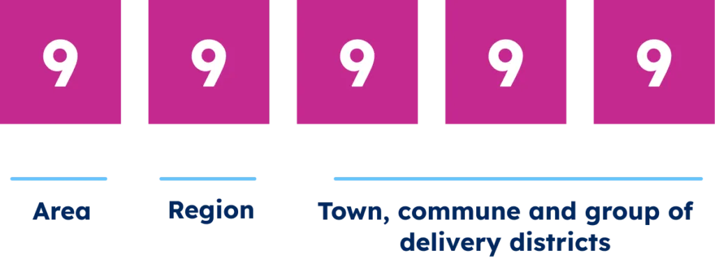
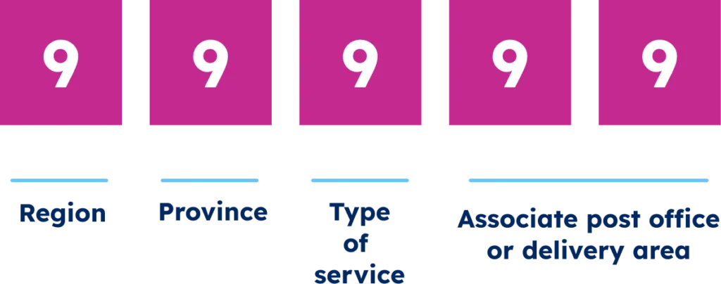
The United States Postal Service introduced the Zone Improvement Plan (ZIP) code system in 1963, fundamentally transforming mail processing nationwide. This five-digit numeric code creates a hierarchical geographic division: the first digit identifies one of ten significant regions, the next two represent sectional centers, and the final two specify local delivery areas.
In 1983, the USPS implemented ZIP+4, adding four digits to identify specific street segments or high-volume recipients. This enhancement delivers particularly valuable precision in urban settings where a single ZIP code might cover thousands of delivery points.

The American system illustrates the essential balance in postal coding: sufficient granularity for accurate delivery while being simple for public adoption. While the U.S. achieves this purely numerically, international systems often have different structures and features to address similar fundamental challenges.
Postal Codes Around the World
Let’s explore how different regions have developed their unique postal systems, from Europe’s alphanumeric innovations to Africa’s emerging infrastructures. Each system reflects local geographical and administrative needs.
European Postal Systems: Alphanumeric Innovation
European countries have the most complicated postal code structures worldwide, frequently combining letters and numbers for exceptional precision.
The United Kingdom’s advanced postal code system, developed in the 1960s, uses a two-part format: an outward code (“SW1A”) indicating the postal district and an inward code (“1AA”) identifying specific streets or properties.

The Netherlands implements a four-digit plus two-letter format (1234 AB) covering about 25 houses per code.

France employs a five-digit numeric system (code postal) with the first two digits corresponding to départements.

Germany’s five-digit Postleitzahl (PLZ) similarly divides the country into regions and districts, evolving significantly after reunification in 1990.
These European systems reflect each nation’s administrative structure, population density, and historical development—creating tailored mechanisms for efficient mail delivery.
Asian Postal Systems: Diverse Approaches to Complex Territories
Asia presents some of the most fascinating postal code implementations, addressing challenges like dense urban centers, complex writing systems, and rapid economic development.
Japan’s postal code system (郵便番号, Yūbin Bangō) consists of seven digits formatted as three digits, a hyphen, and four digits (e.g., 123-4567). The first three digits identify the region and city, while the last four specify districts or blocks.
This highly structured approach helps navigate Japan’s dense urban environments where addressing can be particularly challenging due to the non-sequential nature of many Japanese addressing schemes.

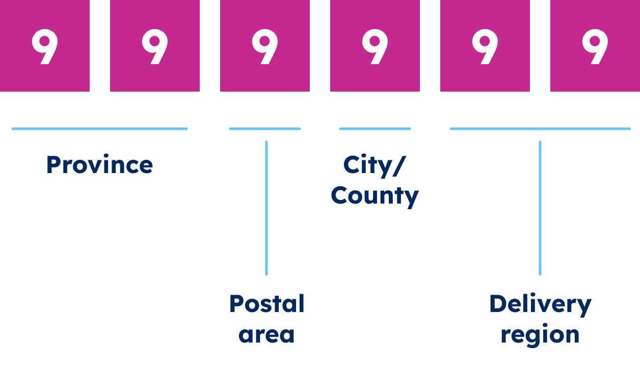
Despite its vast territory and enormous population, China recently implemented its postal code system. Chinese postal codes consist of six digits, with the first two representing the province or municipality, the middle two indicating the prefecture or city, and the final two specifying a delivery zone.
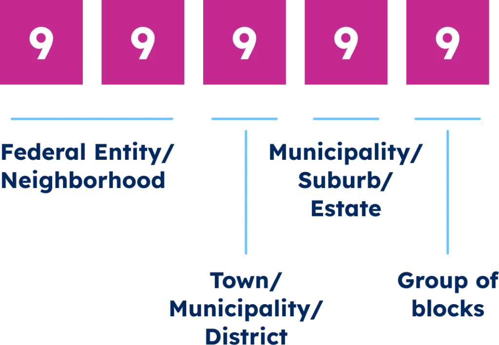
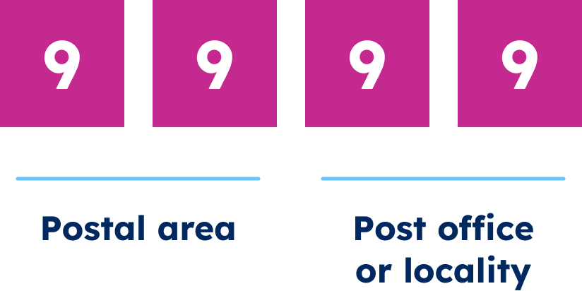
India employs a six-digit Postal Index Number (PIN) code, where the first digit represents one of the nine postal zones, and subsequent digits narrow down to the sorting district and delivery post office.

The diversity of Asian postal systems reflects varying stages of economic development, historical trajectories, and cultural approaches to address. In many Asian countries, rapid urbanization and economic growth have required multiple revisions of postal systems in recent decades, demonstrating how postal codes evolve alongside the societies they serve.
North and South American Systems: Regional Variations
Beyond the United States, the Americas feature diverse postal code implementations reflecting each country’s geographic characteristics, administrative structure, and historical evolution.
Canada employs a six-character alphanumeric system (A1A 1A1) called the Postal Code. The first three characters (Forward Sortation Area) designate geographical regions within cities or rural areas, while the final three (Local Delivery Unit) identify specific neighborhoods or high-volume recipients.

Mexico uses a five-digit numeric Código Postal with the first two digits corresponding to its 32 states, creating direct alignment between administrative and postal boundaries.
Brazil implements an eight-digit CEP (Código de Endereçamento Postal) formatted as five digits, a hyphen, and three more digits, enabling navigating complex urban environments and extensive rural regions.

Other South American nations generally utilize numeric systems with varying precision levels. These diverse approaches demonstrate how countries adapt universal sorting principles to their specific geographic and demographic contexts, balancing technical efficiency with practical usability.
Africa and the Middle East: Emerging and Evolving Systems
Africa and the Middle East have varied addressing landscapes, with significant contrasts in postal code implementation and sophistication.
South Africa utilizes a straightforward four-digit numeric code identifying specific delivery offices.
Egypt employs a five-digit system with the initial digit designating the governorate.
Saudi Arabia uses a five-digit numeric code, providing precise geographic sorting information.
However, numerous African nations continue to operate without formal postal codes, relying on post office boxes, city names, and regional indicators for mail sorting.
While countries like Ghana, Ethiopia, and Kenya are working to expand postal code coverage, implementation faces substantial challenges related to infrastructure limitations, rural addressing complexities, and public adoption barriers.
These regional variations illustrate how postal systems develop along a continuum. Implementation typically reflects a country’s infrastructure development, urbanization patterns, and economic priorities.
Understanding Structural Differences in Global Postal Codes
Different countries approach postal codes with varying formats and organizational principles. Let’s examine the key structural differences that impact how these systems function across borders.
Numeric vs. Alphanumeric Systems
| Category | Numeric Systems | Alphanumeric Systems |
|---|---|---|
| Format | Digits only | Letters + numbers |
| Examples | US, France, Japan | UK, Canada, Netherlands |
| Length | 4–7 digits | It may cause issues in numeric-only systems |
| Precision | Needs more digits for precision | High precision with fewer characters |
| Compatibility | Works well with numeric systems | May cause issues in numeric-only systems |
| Use Factors | Simple, legacy-friendly | Usually six characters |
A foundational distinction exists in global postal systems’ elemental character composition: purely numeric versus alphanumeric formats.
Numeric systems (US, France, Japan) use only digits (4-7 numbers), offering simplicity and keypad compatibility but requiring more digits for precision.
Alphanumeric systems (UK, Canada, Netherlands) combine letters and numbers, creating compact codes with greater information density.
Despite containing just six characters, the UK’s “SW1A 1AA” format can pinpoint areas as precise as specific buildings or small address clusters. They offer superior precision with fewer characters, though they may cause compatibility issues in systems optimized for numeric-only data.
The implementation choice typically reflects population density, postal history, administrative boundaries, addressing conventions, and usability. For international businesses, this distinction requires validation processes that accommodate both formats.
Hierarchical vs. Non-hierarchical Structures
| Category | Hierarchical Systems | Non-Hierarchical Systems |
|---|---|---|
| Structure | Codes reflect geographic levels | No spatial order in codes |
| Examples | US, Germany, China | Some operational-focused systems |
| Logic | Nested, progressive digits | Operational over geographic logic |
| Benefits | Enables spatial grouping | Prioritizes delivery efficiency |
| Challenges | Needs country-specific knowledge | Harder to infer location |
| Use Cases | Clustering, segmentation, logistics | Purely routing-focused tasks |
A critical structural distinction in postal code systems involves hierarchical versus non-hierarchical geographic organization.
Hierarchical postal systems (US, Germany, China) embed geographic relationships in code structure. For example, U.S. ZIP codes identify regions with the first digit, then narrow them down to specific areas.
Non-hierarchical systems assign codes without geographic progression, prioritizing operational efficiency.
A country’s approach impacts business applications like clustering, territory management, logistics, and market segmentation. While hierarchical systems enable geographic inference, implementation requires knowledge of each country’s specific structure.
Precision and Coverage Variations
| Category | High-Precision Systems | Low-Precision Systems |
|---|---|---|
| Precision | Identifies buildings or small clusters | Covers large areas, e.g., towns |
| Examples | UK, Netherlands | Rural or developing regions |
| Coverage | Nationwide, complete | Urban-focused or post office-based |
| Use Cases | Accurate delivery, service area mapping | Broad delivery zones |
| Business Impact | Supports detailed analysis and routing | May reduce accuracy |
| Implementation Tip | Tailor by country for reliable data use | Combine with other data when needed |
Global postal systems vary greatly in precision and coverage.
High-precision systems (UK, Netherlands) can identify specific buildings, while lower-precision ones may cover entire towns.
Coverage completeness differs too – some countries maintain comprehensive coding nationwide, while others focus on urban centers or use post office boxes instead of geographic zones.
These differences affect business functions like address verification, delivery estimates, service areas, and market analysis.
International organizations must understand each country’s precision characteristics, as location references that work in one market may be inadequate in another.
Challenges of Global Postal Systems that Companies Will Face
While postal codes are essential for many business operations, their diverse global implementations create significant challenges for companies operating across borders. Let’s examine the key obstacles businesses encounter when working with international postal systems.
Finding Reliable Data Sources
The first major challenge for businesses is identifying trustworthy postal data sources across different countries. Quality varies tremendously between sources, with several key factors determining reliability:
- Authoritative Source: Postal codes are created through practical and legal decisions by postal operators and governments. Using unofficial sources can lead to misdelivered packages, failed address validations, and customer service issues.
- Up-to-date Information: Postal organizations regularly create, replace, or remove codes, sometimes without broad announcements. National postal services and governmental databases typically maintain the most current information, but international aggregators may lag behind these changes.
- Technical Accuracy: Businesses need sources with valid coordinates and correct attributes for each postal code. Inaccurate data leads to mapping errors, incorrect distance calculations, and flawed market analysis.
- Data Model Clarity: Sources with straightforward, well-documented data models save considerable implementation time and reduce error potential.
Designing a Unified Data Model
Building a unified data model for global postal systems is also a significant technical challenge. Companies must develop structures that handle both alphanumeric (like Canada’s “K1A 0A9”) and numeric formats (like Japan’s “123-4567”) within the same system.
The key challenge lies in designing a generic data model that accommodates local constraints within a global framework. This often requires developing:
- A consistent hierarchical structure that works across all countries
- Flexible field formats that handle diverse character sets and postal code patterns
- Appropriate relationships between postal codes and administrative divisions
- Standardized validation rules that adapt to country-specific requirements
E-commerce platforms have invested heavily in adaptive address models that maintain consistency across diverse markets while respecting local postal formats.
Pre-processing and Extracting Information
Address formats differ dramatically across countries, creating data processing challenges. The above-mentioned examples (such as the postal codes in the UK, Japan, and Germany) reflect these potential issues.
These variations force companies to develop country-specific data extraction and standardization processes.
E-commerce businesses typically need advanced address parsing systems that can:
- Identify postal code positions within address strings
- Extract key elements regardless of format or order
- Normalize data across different standards
- Handle country-specific abbreviations and terminology
Global shipping companies maintain extensive rules engines that process addresses differently based on the origin country, allowing them to operate efficiently across diverse postal systems.
Linking to Administrative Divisions
Businesses must often connect postal codes to administrative divisions for regulatory compliance, tax purposes, and regional analytics. However, the relationship between postal areas and government jurisdictions varies between countries.
Companies typically encounter challenges such as:
- Misaligned boundaries between postal zones and administrative regions
- Different levels of administrative hierarchy across countries
- Changing administrative borders without corresponding postal code updates
- Multiple naming conventions for the same administrative areas
Companies doing regional analysis or managing territorial responsibilities must develop detailed mapping between postal and administrative boundaries. This often requires combining multiple reference datasets and creating country-specific relationship tables.
Geocoding Postal Data
Businesses must convert postal codes to geographic coordinates when implementing location-based services or logistics operations. The varying precision of postal systems worldwide makes this process inconsistent and complex.
The precision gap of postal codes forces companies to:
- Implement different geocoding strategies by country
- Use postal code centroids in some regions while requiring full addresses in others
- Develop confidence scores for geocoding results based on regional precision
- Create fallback mechanisms for areas with limited postal coverage
Ride-sharing applications and delivery services must consider these precision variations when estimating pickup times.
Linking Different Location Standards
International businesses often need to connect postal data with other location standards used in specific industries or regions.
Standards like ISO3166-2, NUTS codes (Europe), FIPS codes (US), and UN/LOCODES (transportation) often need to be mapped to postal codes for regulatory reporting, analytics, and systems integration.
This linking process faces several obstacles:
- String matching challenges (capitalization, punctuation, abbreviations)
- Different languages and scripts for the same locations
- Asynchronous updates between different standards
- Varying levels of granularity between systems
Financial institutions, which must report activities by region according to multiple regulatory frameworks, often maintain complex correspondence tables between postal codes and different international location standards.
Maintaining Data Quality and Consistency
Perhaps the most persistent challenge for global businesses is maintaining high-quality postal data over time.
Postal systems evolve continuously, with changes including:
- Creation of new postal codes in developing areas
- Boundary adjustments in existing codes
- Complete system overhauls (like South Korea’s 2015 transition from 6-digit to 5-digit codes)
- Administrative reorganizations affecting postal hierarchies
Companies must implement ongoing data quality processes:
- Regular updates from authoritative sources
- Validation testing against country-specific postal formats
- Geographic consistency checks between postal codes and localities
- Monitoring for significant system changes across markets
Global shipping companies typically update their postal databases monthly or even weekly to maintain accuracy, with emergency updates for significant system changes.
Critical Business Impacts of These Challenges
The complexity of global postal systems directly affects several critical business functions:
- Customer Experience: Address validation failures frustrate customers and increase cart abandonment rates. Online shoppers may abandon purchases when experiencing checkout complications, including address validation issues.
- Delivery Performance: Inaccurate postal data leads to failed deliveries.
- Compliance Risk: Inadequate location data creates regulatory exposure, particularly for financial services and healthcare organizations with strict regional reporting requirements.
- Market Analysis Inconsistency: Varying postal precision undermines comparative market analysis across regions, leading to potential strategy misalignments.
How Companies Overcome These Challenges
Despite the complexity, companies across industries can find practical ways to work with the following systems to improve operations and support international growth.
Maintaining Comprehensive Postal Code Data
For international organizations, maintaining accurate postal code data represents a significant ongoing challenge as systems worldwide undergo regular updates with shifting boundaries, new codes, and occasional complete revisions.
Effective postal data management requires reliable update mechanisms from authoritative sources and country-specific validation rules. It also needs version control to track historical changes, fallback mechanisms for limited-coverage countries, and flexible data models to accommodate diverse formats.
Many organizations partner with specialized location data providers rather than maintaining this information independently, achieving better accuracy at lower cost.
Implementing Flexible Address Validation
Accurate address validation is a fundamental application of postal code data for international businesses.
International address validation requires systems adapting to each country’s unique postal format, field requirements, and conventions. One-size-fits-all approaches inevitably fail to address diversity.
Best practices include country-specific validation rules, adaptive required fields based on regional addressing norms, proper formatting, non-Latin characters, administrative hierarchies, and regional exceptions. They also need to recognize alternative addressing approaches where postal codes aren’t used and balance validation that accommodates local variations.
The business implications are substantial. This adaptive approach allows customers worldwide to enter addresses in familiar formats while maintaining data quality for successful delivery and analysis.
At the same time, precise address validation effectively reduces delivery failures and ensures compliance with local addressing requirements. All of them are critical factors for successful international commerce operations.
Building Location Intelligence Beyond Postal Codes
While valuable, postal codes are enhanced by comprehensive location intelligence incorporating additional spatial data layers. Advanced location strategies combine postal code boundaries with administrative divisions, transportation networks, points of interest, demographic indicators, and natural geographic features.
This multi-layered approach creates robust location intelligence that overcomes the limitations of any single geographic reference system. It provides alternative analysis points when postal codes lack precision in certain regions.
Strategic Global Postal Intelligence for Business Success
Successful international operations require strategic approaches to global postal variations. When companies clear all the possible obstacles by applying these strategies, they can further develop their businesses in many aspects:
Logistics and Supply Chain Optimization
In logistics operations, postal codes are the key for route optimization, delivery time estimation, and distribution network design.
Companies need to navigate several critical variations. Among them are country-specific geographic precision differences, incorrectly calculated delivery time based on postal codes, coverage gaps in rural or developing regions, and market-specific delivery regulations.
Logistics systems integrate country-specific postal intelligence with precise coordinates and regional delivery patterns, especially for areas with limited postal coverage.
Geocoding and Spatial Analysis
Converting postal codes into geographic coordinates allows for spatial analysis. However, you already know that the implementation complexity varies across countries due to postal code precision differences. Therefore, markets with limited postal infrastructure need alternative geocoding strategies entirely.
Companies conducting global spatial analysis must adapt methodologies to each country’s postal precision characteristics.
Also, they should implement various approaches, including postal centroids, precise address point data, postal code boundary polygons, or hybrid solutions combining multiple reference datasets.
These tailored approaches ensure consistent analytical results despite the underlying structural differences in national postal systems.
Market Analysis and Territory Management
Despite different analytical utilities across national systems, postal codes function as foundational geographic units for market analysis, territory planning, and business intelligence.
In structured systems like Germany’s and Japan’s, postal codes follow consistent hierarchical patterns that align with administrative boundaries and population distributions, creating ideal units for market segmentation.
However, in many countries, postal boundaries often reflect historical operations rather than market divisions, with size variations from buildings to rural regions complicating consistent analysis.
International businesses conducting location-based market analysis can account for these differences by:
- Developing country-specific geographic hierarchies
- Normalizing data across different postal precisions
- Supplementing postal data with additional geographic information
- Creating custom territories that adapt to local postal structures
This customized approach enables consistent global analysis despite the underlying variations in postal systems.
Conclusion
Navigating global postal systems presents challenges and opportunities for international businesses. The variations in structure, precision, coverage, and terminology across countries reflect unique historical developments and administrative approaches, creating a complex global addressing mosaic.
Mastering these differences delivers concrete advantages for cross-border organizations: improved customer experience through accurate address handling, enhanced delivery performance, and more precise location-based analysis.
This approach also ensures better compliance with local regulations and provides a competitive advantage in markets with complex challenges.
At GeoPostcodes, we’ve spent over 15 years building the world’s most comprehensive postal code database covering 247 countries. Our data encompasses postal codes and administrative divisions, cities, boundaries, and demographic information—providing a complete location intelligence foundation for global operations.
Whether validating international addresses, implementing location services, analyzing markets, or optimizing logistics networks, accurate postal data provides essential geographic context for success in today’s global marketplace.
We invite you to browse our data for free and download a free sample here. Feel free to discover how precise location intelligence can transform your international operations and request a quote.
FAQ
Do ZIP codes exist in other countries?
While most countries have postal code systems, the term “ZIP code” is specific to the United States. Other nations use various formats and terminology such as postcodes (UK), codes postaux (France), or PLZ (Germany).
Which country has no ZIP code?
Approximately 40 nations operate without formal postal codes, including Hong Kong, Bahamas, Angola, Belize, and several smaller island nations where mail delivery relies on alternative addressing systems and post office boxes.
Do other countries use ZIP codes like the U.S.?
Yes, but many use different formats. Canada, for example, has an alphanumeric postal code system. In various countries, the post office system assigns post codes, which postal workers use for sorting and deliveries via the local post office.
Are ZIP codes an American thing?
Yes, “ZIP” (Zone Improvement Plan) is exclusively American terminology. While most countries utilize postal code systems, they employ different names, formats, and structures adapted to their specific geographic and administrative needs.
Is ZIP code 11111 valid?
No, 11111 is not a valid USPS ZIP code. The lowest assigned U.S. ZIP code is 00501 (Holtsville, NY), and no ZIP codes beginning with “1” start with consecutive identical digits.
How do Canadian postal codes differ from ZIP codes?
Canadian postal codes follow an alphanumeric postal code system (e.g., K1A 0B1), unlike numeric U.S. ZIP codes. The post office system assigns them based on geography, helping postal workers at the local post office efficiently sort and deliver mail.
