Introduction
GeoJSON is a robust and flexible format for encoding various geographic data structures. It’s an indispensable tool for anyone involved in geospatial data, leveraging JavaScript Object Notation (JSON) to present vector geometries and associated non-spatial attributes in an easily understandable way.
This format plays a pivotal role in web mapping, geographic information systems (GIS), and applications that demand an accurate depiction of geographic features.
In this article, we’ll explore the MultiPolygon geometry type in detail, discuss how to interchange GeoJSON geometry types, and compare Polygon with MultiPolygon. Additionally, we’ll examine how tools like Shapely can be utilized to convert between these types and ensure your geospatial data is precisely represented in GeoJSON format.
Overview of GeoJSON Geometry Types
GeoJSON supports geometry types such as Point, Line String, Polygon, MultiPoint, Multiline String, and MultiPolygon. The Polygon and MultiPolygon types are especially significant for representing complex geographic shapes. A Polygon forms a closed shape with a sequence of connected points, which may include holes or interior rings.
💡 Power your products with our high‑quality polygons, available in GeoJSON, Shapefile, KML, ASC, DAT, CSV, and GML formats. Visualize our worldwide boundary data for free.
The MultiPolygon type addresses the need to represent a single geographic feature through multiple disconnected polygons. This is particularly useful for depicting entities like countries comprising several islands or states with non-contiguous areas.
Mastering the MultiPolygon geometry in GeoJSON is essential for accurately capturing intricate geospatial data.
Understanding GeoJSON Multipolygon
Definition of a Multipolygon
A MultiPolygon in GeoJSON is a geometry type representing a collection of disjoint Polygon objects. This is particularly useful when describing a geographic feature that consists of multiple separate areas, such as a country with several islands, a state with non-contiguous regions, or any other entity that a single contiguous polygon cannot represent.


GeoJSON Multipolygon Example
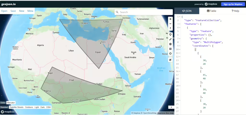
To understand the structure of a MultiPolygon in GeoJSON, let’s look at a simple example. Here is how you might represent a feature that consists of two separate polygons:
{ "type": "MultiPolygon", "coordinates": [ [ [ [30.0, 20.0], [45.0, 40.0], [10.0, 40.0], [30.0, 20.0] ] ], [ [ [15.0, 5.0], [40.0, 10.0], [10.0, 20.0], [5.0, 10.0], [15.0, 5.0] ] ] ] }In this example:
- The “type” member is set to “MultiPolygon”, indicating a MultiPolygon geometry.
- The “coordinates” member is an array of Polygon coordinate arrays. Each Polygon is an array of LinearRing coordinate arrays, where the first ring is the exterior ring and any subsequent rings are interior rings or holes.
The coordinates are ordered as “longitude, latitude” pairs, following the GeoJSON convention. This structure allows you to accurately represent complex geographic features of multiple distinct polygons, making it a powerful tool for geospatial data representation.

What is the difference between a polygon and a MultiPolygon?
Understanding the differences between Polygon and MultiPolygon is essential for accurately representing and manipulating geospatial data when working with GeoJSON.
Structure
- Polygon: A Polygon in GeoJSON is a single, continuous area defined by a sequence of coordinates that form a closed shape. It can include interior rings or holes. The structure of a Polygon involves an array of LinearRing coordinate arrays, where the first ring is the exterior boundary, and any subsequent rings are interior holes.
{ "type": "Polygon", "coordinates": [ [ [30.0, 10.0], [40.0, 40.0], [20.0, 40.0], [10.0, 20.0], [30.0, 10.0] ] ] } - MultiPolygon: A MultiPolygon is a collection of multiple disjoint Polygon objects. Each Polygon within the MultiPolygon is represented as an array of LinearRing coordinate arrays, similar to a single Polygon, but these are grouped under the MultiPolygon type. This allows for the representation of features that consist of multiple non-contiguous areas.
{ "type": "MultiPolygon", "coordinates": [ [ [ [30.0, 20.0], [45.0, 40.0], [10.0, 40.0], [30.0, 20.0] ] ], [ [ [15.0, 5.0], [40.0, 10.0], [10.0, 20.0], [5.0, 10.0], [15.0, 5.0] ] ] ] }
Use Cases
The choice between a Polygon and a MultiPolygon depends on the nature of the geospatial data you are working with.
- Polygon
- Single Continuous Area: If your data represents a single, continuous geographic area without any disjoint parts, a Polygon is the appropriate choice.
- Simplicity: When the data does not require the complexity of handling multiple separate polygons, a Polygon simplifies the representation and manipulation of the data.
- MultiPolygon
- Disjoint Areas: If your data consists of multiple non-contiguous areas that are part of the same feature, a MultiPolygon is necessary. This is common in countries with islands or states with non-contiguous regions.
- Complex Geographies: For features with complex geometries involving multiple separate polygons, a MultiPolygon provides the flexibility to represent these geometries accurately.
Best libraries to work with GeoJSON
As you can see from the data structure shape, it can be tedious to write and manipulate GeoJSON data without a dedicated tool. Fortunately, a lot of libraries exist in every programming language.
Here’s a breakdown of some of the best JavaScript, Python, C#, and Scala libraries available.
JavaScript
Turf.js is one of the most widely used libraries for working with GeoJSON data in JavaScript. It offers a range of functions for spatial analysis and geometry transformations.
Python
For Python developers, GeoPandas is a powerful tool for manipulating GeoJSON. Built on top of pandas, it simplifies operations with geospatial data. Shapely is another useful library that offers geometry-centric tools for working with GeoJSON features. The Fiona library complements these by providing easy input/output for different geographic data formats, including GeoJSON.
C#
In C#, the NetTopologySuite is a robust library that handles geospatial operations, including reading and writing GeoJSON. Additionally, GeoJSON.NET (also known as Newtonsoft.Json.GeoJson) provides a straightforward way to serialize and deserialize GeoJSON data.
GeoJSON and Database Support
GeoJSON is increasingly supported by various database systems, making it easier to store, query, and manipulate geospatial data. Several databases offer native support for GeoJSON, allowing users to integrate geographic features directly into their data models.
- PostgreSQL with PostGIS: PostgreSQL, when extended with the PostGIS extension, provides robust support for geospatial data, including GeoJSON. PostGIS allows users to store GeoJSON data as geometries in the database, enabling complex spatial queries and analyses. You can easily convert between GeoJSON and PostGIS geometries using functions like
ST_GeomFromGeoJSON()for importing andST_AsGeoJSON()for exporting data. - MongoDB: MongoDB supports GeoJSON as part of its document structure. It allows you to store geographic data directly in collections and provides indexing for geospatial queries. This enables efficient searches for features based on geographic coordinates, making it suitable for applications that require real-time geospatial analytics.
- MySQL: MySQL also supports spatial data types, including GeoJSON. With the introduction of spatial functions, you can store and retrieve GeoJSON data, perform spatial calculations, and create indexes for efficient querying. This makes MySQL a viable option for applications that require geospatial capabilities.
- Microsoft SQL Server: SQL Server includes support for spatial data types, which can be used to store GeoJSON data. It allows for spatial indexing and advanced querying capabilities, making it suitable for applications that require detailed geographic analysis.
By leveraging these database systems, developers can effectively manage GeoJSON data, perform spatial operations, and integrate geographic features into their applications. This support enhances the ability to analyze and visualize geospatial data, ultimately leading to more informed decision-making.
How to Visualize GeoJSON
Visualizing GeoJSON data can provide valuable insights into geographic patterns and relationships. It’s important to note that GeoJSON is not an optimal format for data visualization, especially for large volumes of data. Several tools and platforms facilitate the visualization of GeoJSON files, making it easier to interpret the data:
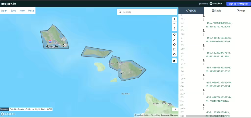
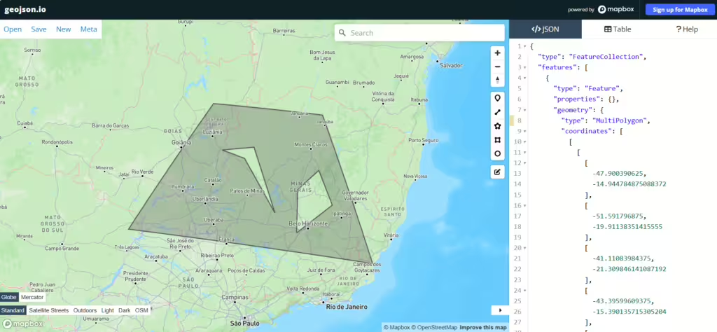
- geojson.io: This user-friendly web-based tool allows users to easily visualize and edit GeoJSON files. Users can drag and drop their GeoJSON files or paste raw GeoJSON data into the interface, instantly rendering the geographic features on the map. It also provides options for exporting the modified GeoJSON data. While it can display multipolygons, it’s not well suited for creating such entities.
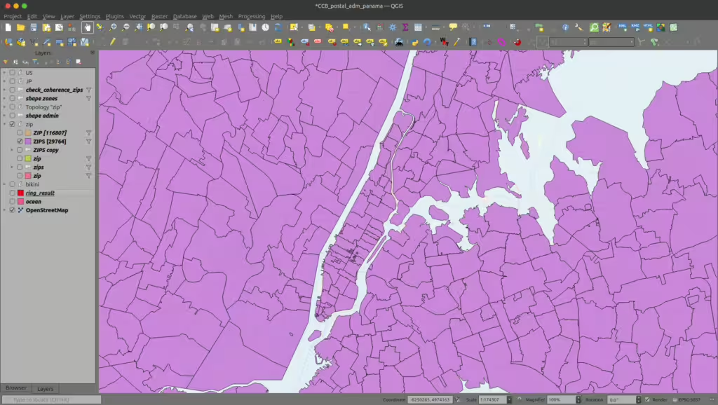
- QGIS: An open-source Geographic Information System (GIS) application, QGIS supports various vector formats, including GeoJSON. Users can import GeoJSON files to create detailed maps, perform spatial analysis, and customize visual representations through extensive styling options. QGIS is ideal for more advanced geospatial analysis and visualization tasks.

- ArcGIS: A powerful GIS platform, ArcGIS offers robust tools for visualizing and analyzing GeoJSON data. Users can import GeoJSON files into ArcGIS Online or ArcGIS Desktop to create interactive maps and perform spatial analytics. The platform provides various visualization options, including 2D and 3D mapping, making it suitable for professional and enterprise-level projects.
These tools provide a range of capabilities for visualizing GeoJSON data, from simple editing to advanced geospatial analysis, catering to different user needs and expertise levels.
Conclusion
In conclusion, mastering the use of Polygon and MultiPolygon geometries in GeoJSON are essential for accurate and effective geospatial data representation. Remember to choose the correct geometry type based on whether your feature is a single continuous or multiple disjoint area.
When necessary, converting between these types requires careful consideration of data integrity and the tools available, such as Shapely.
Understanding these concepts can enhance your GIS analyses, improve web mapping visualizations, and ensure data interoperability. Apply these insights to your projects, and you will significantly improve the precision and utility of your geospatial data.
GeoPostcodes offers boundary data in all popular formats, including geoJSON, with global boundary coverage even in difficult geographies such as China, the UK, Russia, or Brazil. Visualize our boundary data for free.
FAQ
What are the disadvantages of GeoJSON?
The disadvantages of GeoJSON include:
- File size: GeoJSON files can be larger compared to other formats like Shapefile, especially when handling large datasets or complex geometries.
- Performance: Parsing and rendering large GeoJSON files can be slower, particularly in web applications or environments with limited resources.
- Limited Geometry Types: GeoJSON supports only a few geometry types (Point, LineString, Polygon, etc.), which may not be sufficient for complex geographic data.
- No support for projections: GeoJSON uses only WGS 84 (EPSG:4326) and does not support other coordinate reference systems.
- Lack of metadata: Unlike formats such as Shapefiles, GeoJSON doesn’t include built-in support for extensive metadata.
These limitations may affect specific use cases that require higher performance, more geometry types, or advanced spatial analysis.
Can you combine GeoJSON files?
Combining GeoJSON files is a common task when working with geospatial data, particularly when you want to aggregate features from multiple sources into a single dataset.
GeoJSON uses the concept of FeatureCollection, which allows you to group multiple geometries and their associated properties into one cohesive structure.
To merge multiple GeoJSON files, you typically need to extract the features from each file and combine them into a new FeatureCollection.
This can be efficiently done using libraries like Turf.js for JavaScript, GeoPandas for Python, and Shapely for more geometry-centric operations.
- Turf.js: Turf.js offers several functions to combine features, such as
turf.combine()which can merge multiple geometries into a single FeatureCollection. This is particularly useful for tasks like simplifying geometries or merging overlapping features. - GeoPandas: In Python, GeoPandas simplifies the process of combining GeoJSON files. By using the
gpd.read_file()function, you can read multiple GeoJSON files into GeoDataFrames, and then use theconcat()function to merge these frames into one. This approach retains the geometric and attribute data, allowing for seamless analysis and visualization. - Shapely: While primarily focused on geometry manipulations, Shapely can be integrated with GeoPandas for more complex merging tasks. By utilizing functions like
unary_union, you can merge multiple geometries into a single geometric object, which can then be converted back into a GeoJSON format if needed.
Combining GeoJSON files not only streamlines data handling but also enhances your ability to perform comprehensive analyses across various datasets.
By leveraging the capabilities of these libraries, you can efficiently manage and manipulate your geospatial data to derive meaningful insights.
What is a GeoJSON Geometry Object?
A GeoJSON geometry object represents geographical shapes and structures, such as points, lines, and polygons, and it serves as a core building block in GeoJSON files.
Each geometry object represents points in a defined space and can represent complex shapes with multipart structures.
Within GeoJSON, these objects are used in feature and geometry objects that make up FeatureCollection and geometry objects to depict a variety of geographic shapes.
Interpreting geometry objects effectively is essential for spatial data applications.
What Geographic Coordinate Reference Systems are Supported in GeoJSON?
GeoJSON objects are defined based on the geographic coordinate reference system using the WGS84 standard, which is widely compatible with global mapping services.
In addition, reference system transformation parameters allow transformations between different geographic coordinates, ensuring compatibility across mapping platforms.
These coordinate systems enable GeoJSON objects defined within a universal standard, making it easier to interpret geometry objects accurately.
Can GeoJSON Represent Multiple JSON Objects in a Single File?
Yes, GeoJSON allows for multipart geometry objects where members define geometry objects that together represent a single spatial feature.
This functionality is essential when working with complex GeoJSON objects defined to represent multiple JSON objects within a single file.
Scenarios requiring various shapes or regions under a single entity benefit from this capability, enhancing flexibility for geospatial data handling in applications.
What are some alternatives to GeoJSON that can improve performance in data visualization?
While GeoJSON is a popular format for encoding geographic data, it may not always provide optimal performance for large datasets in data visualization.
Here are some alternatives that can enhance performance:
- TopJSON: An optimized version of GeoJSON, TopJSON reduces file size by encoding topology and sharing geometry among features. This can significantly decrease the amount of data transferred, improving rendering times in visualizations.
- FlatGeobuf: This binary format is designed for efficient storage and transmission of geospatial data. It supports fast reading and writing, making it suitable for applications that require quick access to large datasets.
- Shapefiles: While older and more complex, shapefiles are a widely used format in GIS applications. They can be more efficient in certain contexts, especially when working with large volumes of vector data, although they require additional steps for integration into web-based visualizations.
- WKT/WKB (Well-Known Text/Binary): These formats provide a compact representation of geometries. WKT is human-readable, while WKB is more efficient for storage and transmission. They are often used in databases for spatial queries and can be converted to GeoJSON when needed.
Choosing the right format depends on the specific requirements of your project, such as data size, complexity, and the need for interactivity.
By considering these alternatives, developers can optimize performance and enhance the user experience in geospatial data visualizations.


