

Key Takeaways
- Many countries use numeric formats, while others use alphanumeric systems
- Format length ranges from 3 digits to 10 characters by the country’s postal system
- Some countries don’t use postal codes (e.g., Angola, Bahamas), others use a single code nationwide
- Formats can change over time; some countries have both old and new systems in use
Introduction
Have you ever wondered why a zip code in the United States looks different from a postal code in the United Kingdom? Or why some countries don’t even use postal codes at all? These differences are not just enjoyable; they are crucial for businesses operating globally. Understanding them is critical to your success.
What do we mean by zip codes, postal codes, and postcodes? We often use these terms interchangeably, but they can vary significantly from one country to another. For instance, the United States uses “ZIP codes,” while the United Kingdom uses “postcodes.”
Why does it matter for your business to know these variations? If your company handles international shipments, processes addresses for global customers or uses location-based data, understanding the correct format and usage of postal codes is essential. Incorrect or improperly formatted postal codes can lead to delays, undelivered goods, or lost business opportunities.
🔗 Take a look at the data table below, which you can download for free, to compare the international postal code formats of different countries:
| ISO | Country | Sovereign | Postal format | Postal name |
|---|---|---|---|---|
| AD | Andorra | AD999 | Postal code | |
| AE | United Arab Emirates | – | – | |
| AF | Afghanistan | 9999 | Postal code | |
| AG | Antigua and Barbuda | – | – | |
| AI | Anguilla | GB | AI-2640 | Postcode |
| AL | Albania | 9999 | Kodi Postar | |
| AM | Armenia | 9999 | Փոստային ինդեքս | |
| AO | Angola | – | – | |
| AR | Argentina | A9999 AAA | CPA | |
| AS | American Samoa | US | 96799 | ZIP code |
| AT | Austria | 9999 | PLZ | |
| AU | Australia | 9999 | Postcode | |
| AW | Aruba | NL | – | – |
| AX | Åland | FI | 99999 | Postnummer |
| AZ | Azerbaijan | AZ 9999 | Poçt indeksi | |
| BA | Bosnia and Herzegovina | 99999 | Poštanski broj | |
| BB | Barbados | 99999 | Postal code | |
| BD | Bangladesh | 9999 | Postal code | |
| BE | Belgium | 9999 | Code postal | |
| BF | Burkina Faso | 99999 | – | |
| BG | Bulgaria | 9999 | Пощенски код | |
| BH | Bahrain | [9]999 | Block | |
| BI | Burundi | – | – | |
| BJ | Benin | – | – | |
| BL | Saint Barthélemy | FR | 99999 | Code postal |
| BM | Bermuda | GB | AA 99 | Postcode |
| BN | Brunei Darussalam | AA9999 | Postal code | |
| BO | Bolivia | – | – | |
| BR | Brazil | 99999-999 | CEP | |
| BS | Bahamas | – | – | |
| BT | Bhutan | 99999 | Postcode | |
| BV | Bouvet Island | NO | – | Postnummer |
| BW | Botswana | – | – | |
| BY | Belarus | 299999 | Паштовы індэкс | |
| BZ | Belize | – | – | |
| CA | Canada | A9A 9A9 | Postal code | |
| CC | Cocos (Keeling) Islands | AU | 6799 | Postcode |
| CD | Congo, Democratic Republic | 9999999 | Code postal | |
| CF | Central African Republic | – | – | |
| CG | Congo-Brazzaville | – | – | |
| CH | Switzerland | 9999 | NPA | |
| CI | Côte d’Ivoire | – | – | |
| CK | Cook Islands | NZ | – | – |
| CL | Chile | 9999999 | Código postal | |
| … | … | … | … | … |
🔗 You can download the table above for free for practical application. It provides a first-level validation of the postal code system, which can be helpful when designing address forms or data standards for your business.
Understanding Zip Code Formats Worldwide
Different countries use varied systems for their postal codes, also known as zip codes, postcodes, PIN codes, CAP codes, or Eircodes. These systems are crucial in sorting and delivering mail and global logistics.
Imagine sending a shipment to Germany without the correct “PLZ” (Postleitzahl) or trying to map customer locations in Brazil without understanding their “CEP” (Código de Endereçamento Postal) system.
💡 For over 15 years, we have created the most comprehensive worldwide zip code database. Our location data is updated weekly, relying on more than 1,500 sources. Browse GeoPostcodes datasets and download a free sample here.
Each country has a unique way of structuring postal codes that reflects its geographic, administrative, and logistical needs. For example, Canadian postal codes are alphanumeric and formatted as “A1A 1A1,” indicating specific areas down to a neighborhood level.
In contrast, In Saudi Arabia, they use five-digit all-numeric postal codes.
Japanese postal codes use a longer numerical format like “123-4567,” designed to facilitate efficient mail distribution within densely populated cities.
But knowing the format is not enough. The terminology also changes. In Australia, they’re called “postcodes,” in Italy, “CAP,” and in France, “code postal.” Each name carries its own rules and structure, which can be a labyrinth for businesses without the right tools and knowledge.
So, how can your business handle postal codes correctly across different regions?
Understanding global postal codes is critical to success, whether you’re expanding into new markets or optimizing your current processes. This guide will cover the fundamental aspects of zip code formats worldwide, provide illustrative examples, and share insights on navigating the international zip code format.
The Basics of a Postal Code System
Postal codes vary significantly in length, structure, and format, tailored to each country’s specificity. Some codes are purely numeric, while others combine letters and numbers. The structure can be fixed or variable in length, and it may follow a hierarchical order or be assigned randomly.
Worldwide, postal codes have various names. In the United States and the Philippines, they are called ZIP codes, an acronym for Zone Improvement Plan. Italy uses CAP codes for Codice di Avviamento Postale, while Ireland assigns unique Eircodes to each address. India’s system uses PIN codes or Postal Index Numbers, which are straightforwardly called postal codes in Canada.
Postal Code Format Variations Across Continents
Postal code formats and usage vary worldwide, reflecting geographical, administrative, and cultural differences.
Europe
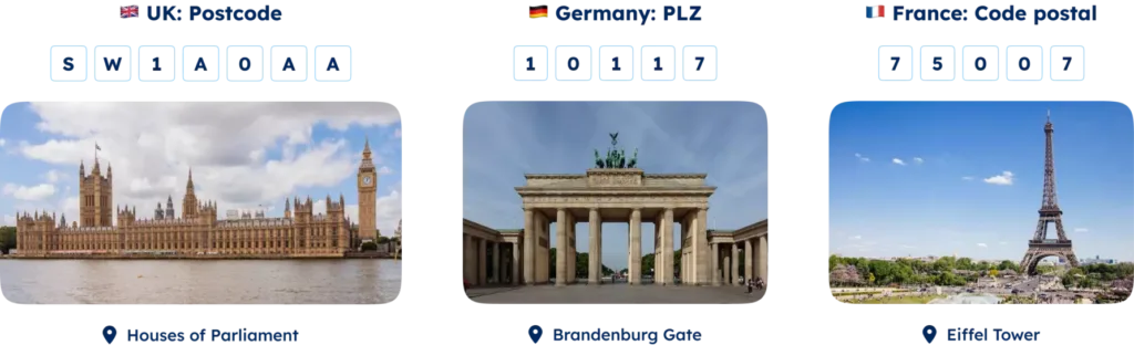
In Europe, most countries opt for a four or five-digit numeric code. Notable exceptions include the UK and the Netherlands, which use alphanumeric postcodes of six to eight characters. Germany and France employ five-digit codes that start with a regional digit, similar to Spain and Portugal’s system, which uses the first two digits to represent the province.
North America
In North America, a five-digit numeric code prevails, with the US incorporating an optional four-digit extension for precision. Canada refers to them as postal codes, while Mexico‘s system includes a five-digit code, indicating the state with the first two digits.
South America
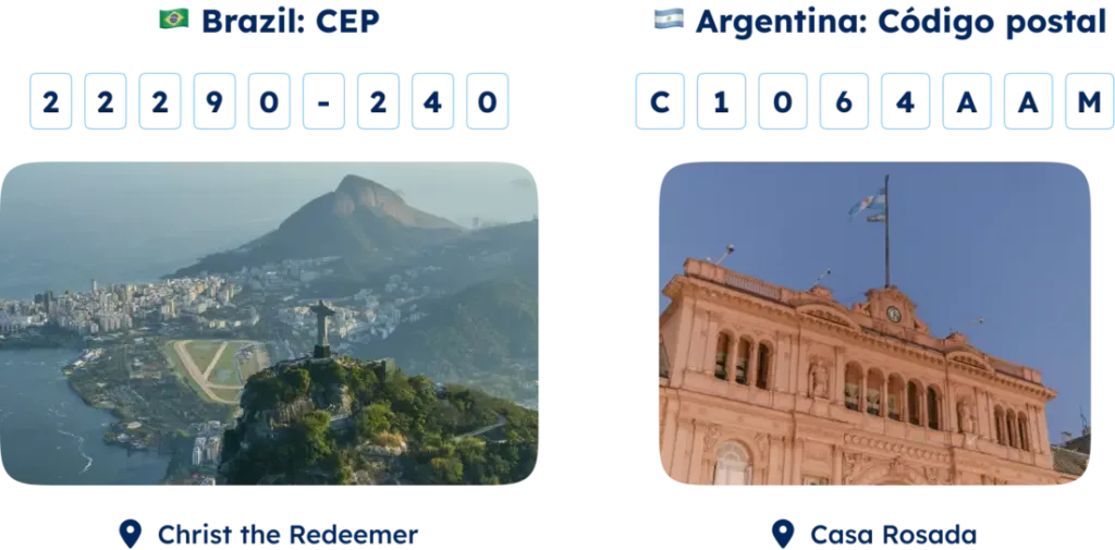
South America generally uses four or five-digit numeric codes. Still, Argentina and Brazil stand out with eight-digit alphanumeric codes, which designate state or region in the first part and city or district in the second. Colombia and Ecuador use a six-digit numeric system, dividing the code between department or province and municipality or parish.
Asia
Asian countries broadly use five or six-digit numeric codes. China and Japan’s systems specify the province or prefecture with the first digits and the city or district with the remaining ones. India and Pakistan start their six-digit codes with a zone indicator, while Singapore and Hong Kong’s six-digit codes uniquely identify sectors or buildings.
South Korea and Vietnam use a five-digit postal code system.

Africa
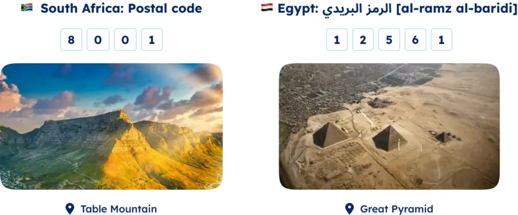
In Africa, where postal systems may be less developed, countries like Nigeria and Ghana employ a six-digit code to signify regions and delivery areas. South Africa and Kenya use a four-digit system, indicating the province or county, whereas Egypt and Morocco’s five-digit code denote the city or zone.
Oceania
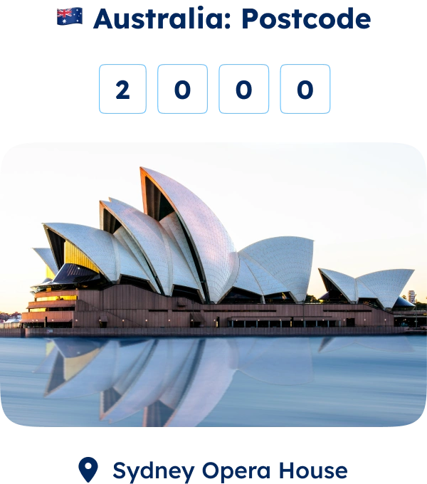
Oceania’s approach typically involves a four-digit numeric code, with Australia and New Zealand indicating state or island with the first digit. Papua New Guinea and Fiji use a three-digit code representing the province or division.
Understanding these diverse formats is crucial for businesses engaged in international logistics, ensuring accurate address data and efficient delivery. GeoPostcodes offers comprehensive data solutions to help navigate these complexities, enabling smoother global operations.
Decoding Zip Code Structures in Some Countries
United States ZIP Codes
The United States uses a five-digit numeric zip code system established in 1963 by the USPS. It splits into two segments: the first three digits represent the sectional center facility (SCF), a key mail sorting and distribution hub, while the last two digits pinpoint the exact delivery area, such as a city or rural zone.
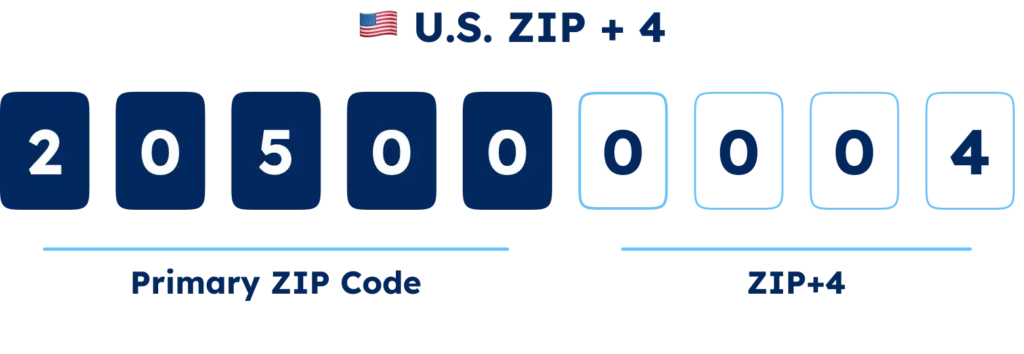
In 1983, USPS introduced a ZIP+4 code system, adding a four-digit extension for a more precise location and enhancing delivery speed and accuracy.
The White House ZIP+4 code is 20500-0004, where “205” is the SCF for Washington, DC, “00” specifies the delivery area, and “0004” pinpoints the exact location within the White House.
Canada’s Postal Codes
Canada’s system, launched in 1971 by Canada Post, features six-character alphanumeric postal codes. It has two halves: the Forward Sortation Area (FSA) and the Local Delivery Unit (LDU), which pinpoint geographic and specific locations, respectively, such as K1A 0A9 for Parliament Hill.
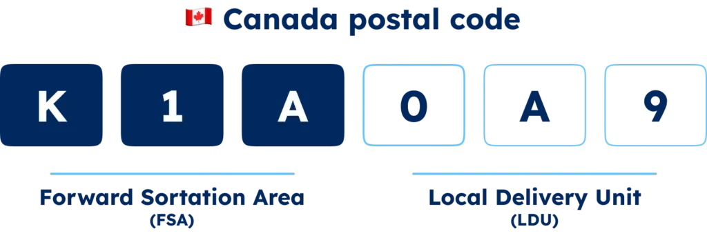
The first character notes the province or territory, with subsequent characters detailing whether the area is urban or rural, the specific area, and the particulars of the LDU, down to the delivery mode.
The UK’s Alphanumeric Postcodes
The UK’s model, started in 1959 by the Royal Mail, is divided into two parts: the outward code for geographic sorting areas and the inward code for specific locales within—for example, SW1A 1AA at Buckingham Palace.

Other Notable Formats
Diverse formats exist globally, such as:
- Japan’s seven-digit code separates prefecture and town/city ward with a hyphen, like 100-0000 for Chiyoda City, Tokyo
- Brazil’s eight-digit postal code, divided by a hyphen to differentiate postal district from a postal suffix, indicating specific internal locations—01000-000 references São Paulo’s central zone
- Argentina adopts an eight-character system, mixing alphanumeric symbols for street segments or delivery points and an older, locality-indicating four-digit code, exemplified by C1000WAZ 1000 for a Buenos Aires segment
How can developers parse and validate postcodes?
For developers managing postal codes, accurate parsing and validation are essential. Parsing extracts details like country, region, city, or specific delivery point, while validation ensures the postal code meets country-specific standards. Here is how to do it:
Regular Expressions (Regex)
Regex defines patterns to identify or capture specific text strings. For example, the regex pattern for a UK postcode is:
^[A-Z]{1,2}[0-9][A-Z0-9]? ?[0-9][A-Z]{2}$
This pattern matches postcodes like “SW1A 2AA” and “M5A 1E1”. Regex is compatible with many languages, including Python, JavaScript, and Ruby.
Challenges
Complexity and Verbosity: Regex patterns can become highly complex and lengthy, making them difficult to read and write.
Maintenance Difficulties: As postal code formats change or new exceptions emerge, updating regex patterns can be cumbersome and error-prone. For instance, developers would need to manually update the regex patterns if a country decides to introduce new postal code formats or modify existing ones. This ongoing maintenance can be tedious and prone to mistakes.
May Not Capture All Variations or Exceptions: Regex might need to fully capture the diverse postal code formats and exceptions across different countries. For example, consider the US postal code “12345-6789” versus “K1A 0B1” in Canada. A single regex pattern may not handle such diverse formats effectively, leading to incorrect validations.
Focus on What Matters with GeoPostcodes
Why struggle with the complexities when GeoPostcodes ensures your data is always reliable and up-to-date? Below are examples of how your business can leverage postal code data:
Address Validation involves comparing entered addresses against GeoPostcodes’ verified database to check for accuracy and completeness. Address Validation prevents delivery errors and ensures packages reach their destinations without issues, which is crucial for e-commerce and logistics.
Autocomplete speeds up the address entry process by providing real-time suggestions as users type, using GeoPostcodes’ precise data. Address Autocomplete enhances user experience, reduces input errors, and mainly benefits online retail and food delivery services.
Master Data Management (MDM) keeps your address database accurate and up-to-date by regularly validating against GeoPostcodes’ reliable data. MDM also ensures correct customer records, which are essential for compliance and risk management in finance and healthcare.
Mapping and Visualization use GeoPostcodes’ data to create detailed maps for analysis and planning. Accurate mapping is crucial for industries like real estate, insurance, and urban planning to make informed decisions.
If you’re looking to discover more ways to leverage ZIP code data for enhanced business insights and efficiency, explore how to add geocoded ZIP codes to Salesforce, ensure accuracy with address validation in Microsoft Dynamics 365, create impactful visuals by mapping ZIP codes in Tableau, and optimize logistics by calculating distances between ZIP codes using Python.
Conclusion
Understanding zip code formats worldwide is crucial for any business operating globally. Zip, postal, and postcodes vary significantly across countries, each with unique formats and rules. This complexity can lead to challenges in international shipments, customer address management, and logistics.
At GeoPostcodes, we partner with you to simplify these complexities. Our comprehensive, accurate, and up-to-date postal code data ensures your operations run smoothly. Here’s how we can help:
- Ensure Accurate Deliveries: Validating addresses against our reliable database prevents delivery errors, ensuring your packages reach their destinations without issues.
- Enhance User Experience: You can use GeoPostcodes data in your real-time address suggestions, speeding up and improving the accuracy of address entry. Address Autocomplete is particularly beneficial for e-commerce and online services.
- Maintaining Data Integrity: Regularly validating your address database against our data can keep your records accurate and up-to-date, essential for compliance and analytics.
- Make Informed Decisions: Use our location data for market analysis, risk assessment, and strategic planning. Accurate postal code data is crucial for making informed business decisions.
With GeoPostcodes, you can save time and resources, enhance accuracy, and improve efficiency. Ready to eliminate the complexities of postal code management and boost your business efficiency? Discover how GeoPostcodes can support your business today, allowing you to concentrate on what you do best.
FAQ
What is a zip code format?
A zip code format denotes the method of expressing a postal code for a particular area in the United States. The standard format uses five digits.
Meanwhile, the ZIP+4 or extended format includes the basic five digits followed by a hyphen and four additional digits. These extra numbers further pinpoint a more specific region within the larger zip code area.
What are the four types of ZIP Codes?
ZIP Codes come in four main varieties:
Standard: Covers broader geographic areas and represents the majority of ZIP Codes.
Unique: Assigned to singular high-volume locations, like government offices or universities.
PO box-only: Exclusively for PO boxes at a specific facility, not for street deliveries.
Military: Allocated for mailing to US military entities, particularly those stationed abroad.
What is the nine-digit zip code format?
The nine-digit zip code, or ZIP+4, extends the standard 5-digit ZIP code with a hyphen and an additional 4-digit number. This expansion gives a more detailed location within a zip code’s area, often down to delivery points like city blocks or clusters of mailboxes, enhancing postal accuracy.
What are the extra four digits after a zip code?
These extra four numbers, known as the ZIP+4 code, intensify the specificity of a postal code’s five-digit delivery area. They can designate smaller segments, such as specific apartment buildings, office spaces, or even individual local post office boxes, streamlining mail sorting and delivery processes.
What is a zip code lookup?
A zip code lookup is a service that allows users to find detailed information about a specific zip code. This information can include the area it covers, demographic data, and other related information. It’s beneficial for businesses that must verify addresses or analyze geographic trends.
How do postal zones work?
Postal zones are designated areas within a country used by postal services to facilitate the sorting and delivery of mail. These zones help streamline the postal process, ensuring that mail is delivered efficiently and accurately. Each zone typically corresponds to a specific region or district, which helps organize the delivery routes.
What is a postal expedition code?
A postal expedition code is a unique identifier postal services use to expedite mail sorting and delivery. This code is often included on packages and letters to ensure they are routed correctly and reach their destination quickly.
How have modern-day postal codes evolved?
Modern-day postal codes have evolved significantly from their inception. Initially introduced to streamline mail delivery, they have become essential for various applications, including navigation, delivery services, and demographic analysis.
Today’s postal codes are more precise and often integrated with advanced technologies such as GPS and geocoding systems to enhance accuracy and efficiency in various services.
How can I find postal code information using postal service websites?
Postal service websites, such as USPS for the United States, Royal Mail for the United Kingdom, and Canada Post for Canada, offer tools and databases for searching postal codes. Enter the address details on these sites, and they will provide the correct postal code for that location.

