

Introduction
When a shipment arrives at the Port of Shanghai, the difference between seamless customs clearance and costly delays comes down to one key factor: accurate location data. Ambiguous addresses, shifting postal codes, and strict cross-border regulations complicate global shipping.
Logistic players can ensure efficient route planning and regulatory compliance and map reliable locations by integrating validated postal information directly into their logistics network.
💡 Comprehensive postal databases enhance visibility across modern supply chains’ procurement, inventory management, and distribution networks. These databases consolidate location data from several authoritative sources and require weekly updates for accuracy. Browse GeoPostcodes’ database and download a free sample to reduce address-related errors and supply chain costs.
This article explores how precise postal and geospatial data help streamline logistics operations, reduce location-based errors, and improve operational efficiency.
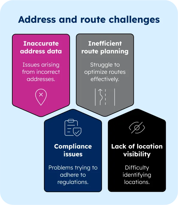
Key Use Cases of Geographical Data in Transportation
In the fast-paced world of logistics, success hinges on precision. Every misplaced package, inefficient route, or regulatory mishap adds to costs and delays. Geographical data plays a crucial role in ensuring seamless operations.
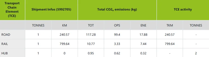
Verifying locations for CO2 calculation
Challenges
- Inconsistencies across countries: ZIP codes and address formats vary widely from country to country.
- Dynamic nature of ZIP code data: ZIP codes can change frequently due to updates in town boundaries or new urban developments.
- Geocoding accuracy: Inaccurate coordinates can lead to inefficient route planning, higher fuel costs, and delayed deliveries.
- Quality control in multi-sourced data: Aggregating data from multiple providers can result in inconsistencies or gaps, especially when dealing with different data formats, languages, or administrative divisions.
Solution
The foundation of efficient logistics lies in the accuracy of your origin and destination locations, to which a pair of latitude and longitude coordinates are assigned. This level of precision enables companies like CarbonCare to compute CO2 calculations for multimodal transportation on a global scale. As one of their analysts said, “With a reliable, global zip code database, we can now successfully estimate CO₂ consumption for more than 4 billion shipments every year.”
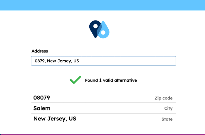
Validating addresses at input to improve customer satisfaction
Before a package leaves the warehouse, one critical question must be answered: Is the delivery address correct?
Challenges
- Misdirected deliveries: Packages sent to the wrong location due to formatting inconsistencies or outdated address records
- Delays and increased costs: Drivers may waste time searching for the correct address or making multiple delivery attempts
- Customer dissatisfaction: Late or failed deliveries damage customer trust and brand reputation
Solution
Address validation and standardization ensure shipments reach the right destination and reduce supply chain costs, including returns and failed deliveries.
Global logistics leaders like DB Schenker leverage validated postal data. This allows them to streamline delivery processes, minimize errors, and improve customer satisfaction.
Last-mile supply chain optimization
Challenges
Shipping companies face several challenges that can impact efficiency and cost-effectiveness:
- Inaccurate delivery time estimates (ETAs): Without precise geolocation at the street and suburb level, carriers often provide overly broad delivery windows, leading to poor customer experiences.
- Route deviation and delay detection: The integration of unreliable geocoded data can lead to the inability to detect when shipments deviate from planned routes or encounter delays.
- Last-mile inefficiencies: In dense urban areas or rural zones with limited data, last-mile routing becomes inefficient, affecting delivery speed and cost-effectiveness.
Solution
By using accurate addresses, postal boundaries, and geocoded data, carriers can:
- Optimize last-mile delivery by adjusting routes based on granular, up-to-date address data.
- Integrating accurate address data allows logistics managers to track shipments proactively, instantly detecting deviations or delays and responding accordingly.
By following these tips, shipping companies can offer more reliable ETAs, enhancing customer satisfaction and operational efficiency.

Tariff calculation
Challenges
- Unforeseen costs: Many shipping companies struggle with hidden charges due to imprecise or outdated geolocation and zoning data, resulting in incorrect tariff application and last-minute routing costs.
- Inaccurate distance estimates: When distance calculations rely on incomplete address or postal data, they often fail to reflect the actual travel cost—particularly for cross-border or rural destinations.
- Inefficient zone pricing: Zone-based pricing models often rely on outdated postal code groupings, leading to inconsistencies and inaccurate rate structures.
Solution
By using accurate addresses, postal boundaries, and geocoded data, carriers can:
- Distance-driven tariff calculation: Accurately geocoded zip code and address data enables precise distance and fuel consumption calculations, supporting accurate pricing across local and international routes.
- Zone-based pricing: Shipping companies can realign their pricing zones for consistency and profitabilitywith detailed postal boundaries and consistent administrative zones.
- Error reduction in tariff application: Access to accurate geocoded and administrative data minimizes misclassifications and ensures correct tariff codes are used from the start, reducing the risk of penalty fees and manual corrections.
This accuracy allows shipping companies to reduce detected deviations and offer more reliable ETAs, enhancing operational efficiency.

Multimodal Transportation Planning
The complexity of modern supply chains demands seamless integration between different transportation modes.
Challenges
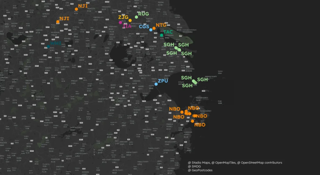
Accurate, up-to-date postal and hub data bridges gaps between sea, air, and land transport. Port-to-rail connections, for instance, require precise terminal locations and enhanced UNLOCODE data to ensure that shipments are correctly routed between various transportation modes.
Large ports with multiple carriers require detailed shipping hub and terminal distribution data to avoid inefficiencies or misrouted shipments.
This challenge becomes particularly acute in large-scale logistics hubs where multiple carriers and transportation modes intersect.
Solution
Accurate postal and shipping hub data is the crucial link between various transportation systems. Port-to-rail connections require precise terminal locations and up-to-date UNLOCODE data.
When coordinating transfers between sea and land transport, having granular data on shipping hubs and port terminal distribution ensures shipments are routed to the correct drop-off point within large ports. This becomes especially critical in significant logistics hubs where multiple carriers and transportation modes intersect.
Designing Smarter Delivery Areas
Efficient logistics isn’t just about moving goods—it’s about knowing where demand is highest and optimizing accordingly.
Challenges
- Inaccurate travel time estimates: Outdated or imprecise coordinates can distort time and distance calculations.
- Suboptimal routing: Transportation managers struggle to identify the best routes, leading to fuel wastage and increased costs.
- Last-mile challenges: Complex urban environments, missing street-level data, or incorrect postal code-to-street mappings make last-mile deliveries inefficient.
Solution
By mapping delivery areas to official country boundaries, companies can fine-tune warehouse placement and ensure shipments travel the shortest possible distance to customers. This also allows logistics teams to predict demand trends, manage stock levels, and allocate resources effectively.
For instance, this global technology provider integrated accurate postal data to compute distances between customer locations and the nearest service centers. This enabled them to optimize warehouse placement, manage inventory levels based on actual service areas, and deliver on strict service level agreements.
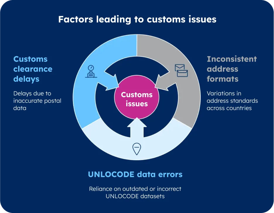
Customs and Regulatory Compliance
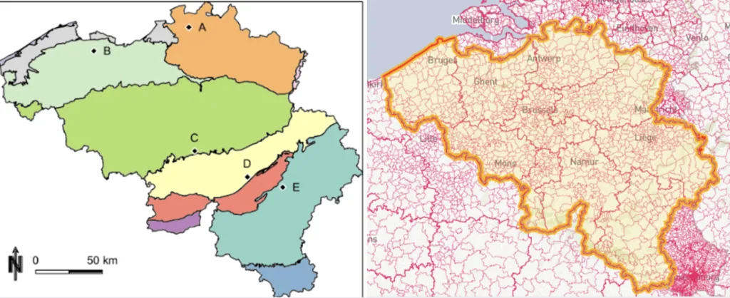
Accurate location data is crucial for customs compliance. Each jurisdiction has specific requirements for postal codes and address formats. Brazil, for example, enforces strict validation rules that require precise alignment between postal codes and customs documentation.
Challenges
- Inconsistent address formats: Addressing standards differ across countries, causing automated processing and customs documentation difficulties
- Errors in UNLOCODE data: Many companies rely on public UNLOCODE datasets, which often contain outdated or incorrect information
- Customs clearance delays: Inaccurate location data can lead to regulatory non-compliance, increasing the risk of customs rejections or fines
Solution
When your location data aligns with current customs requirements, you minimize the risk of:
- Electronic manifest corrections that can cost millions in high-volume ports
- Delays due to address format mismatches
- Compliance issues with local shipping regulations
How GeoPostcodes Supports Your Logistics Operations
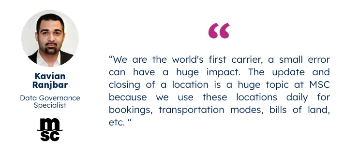
With comprehensive postal and street databases covering over 247 countries, shipping companies such as DB Schenker, MSC, or UPS can confidently validate addresses, reducing failed deliveries.
Our Global Logistics Data Suite offers enriched UNLOCODEs, IATA codes, and port terminal specifications, ensuring smooth cross-border operations.
This data integrates effortlessly with ERP and TMS systems like SAP, Oracle, and Microsoft Dynamics, helping logistics companies optimize routing and supply chain efficiency.

The data is frequently updated, so you can rely on the most current information to minimize errors and delays. And because no two logistics networks are the same, our customizable solutions allow companies to tailor our location data to their unique needs, making every shipment as efficient as possible.
In addition, our team of experts, with more than 15 years of experience, will be dedicated to your account, ensuring smooth integration and timely replies to your questions.
Conclusion
As global supply chains grow more complex, the role of accurate location data in logistics cannot be overstated. From optimizing last-mile deliveries to ensuring seamless customs clearance, precise geo-data is the foundation of efficiency, compliance, and supply chain cost reduction in shipping operations.
The success stories of industry leaders like DB Schenker, MSC, and CarbonCare highlight a clear trend: Companies that leverage high-quality geographical data gain a decisive edge in global logistics.
GeoPostcodes is committed to supporting this evolution. We provide real-time, customizable location data solutions that help companies confidently navigate the ever-changing global shipping landscape.
Improve your logistic operational efficiency and optimize shipping performance with GeoPostcodes. Get a quote now.

